Satellite Navigation commonly known as satnav is regarded as one of the best features of satellite communication. Satellite Navigation is defined as the science that provides the actual information regarding the location and timing services of the user by the use of satellites.
Basically in satellite navigation, a number of satellites are used to identify the user’s location by reading out his coordinates relative to the longitude and latitude of the earth.
The satellite navigation system offering coverage over a global range is coined as Global Navigation Satellite System (GNSS).
Content: Satellite Navigation
Need for Satellite Navigation
The word ‘navigation’ corresponds to the process of accurately determining the position of someone or something (like ships, aircraft, spacecraft, etc.) which moves from one place to another.
Before the technological advancement in radio communications, the navigation for ships and aircraft was achieved through tracing landmarks on earth’s surface and extraterrestrial objects like the sun, moon, etc. This technique was quite inaccurate and along with this, in bad weather conditions, this method of navigation was leading to cause frequent accidents. The reason behind the accidental disasters was that the pilots were relying on landmarks and maps.
After the advent of radio communications, the problem has been solved to some extent. The technical advancements suggested that if the object itself has the knowledge of its location coordinates then such problems will not occur. Thus, using navigation systems, the users themselves be able to locate its coordinate thereby can have their exact location.
How Satellite Navigation takes place?
Till now we have discussed that a satnav system is built with the approach by which the satellite receiver can determine its geospatial positioning (corresponds to a particular three-dimensional position on or above the earth) by using various satellites. Now, the question arises, how the satellite navigation occurs?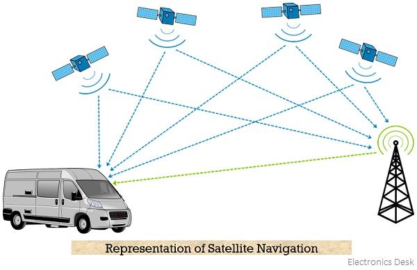
There are a number of satellites that are in operation in space and each satellite emits signals. So, a satellite receiver detects the signals coming from the satellite and then analyses them in a specific manner so as to get their actual current position. Basically, the satellites emit microwave signals having a pulse code. This pulse code contains the information related to the transmitting time along with the current orbital positions of the satellites. Generally, the system must have at least 4 satellites in use that send signals to the satellite receiver to determine the position and time. However, for better accuracy, eight or even more is used for the same.
Once the signal is detected by the satellite receiver then the analysis to get the exact positioning is done. The microwave signals emitted by the satellite generally propagate with nearly the speed of light. The receiver to determine its position performs triangulation by getting signals from the various satellites at the same time. In triangulation, a position is determined by making measurements relative to angles from two locations that are already known.
Furthermore, by determining the difference in time between satellites of known points and receiver, one can evaluate the distance the signal has traveled from the satellite to reach the receiver (as the speed of the signal is already known). Hence, once the distance traveled by the signal is obtained then the receiver can calculate its actual position with respect to the determined distance.
Challenges related to Satellite Navigation
The major issues associated with building a successful satellite navigation system are as follows:
- Lower gravity conditions at the satellites lead to making the clock run slow.
- Earth possesses variable rotational speed thus; correct orbital position must be considered.
- The space weather conditions also affect the signal coming from the satellite towards the receiver.
The above-discussed factors make signal detection quite difficult. While discussing the working, we have considered a general assumption that the signals propagate with the speed of light in a vacuum. This is not exactly true as the earth’s ionosphere does not permit so leading to cause delay in signal arrival. Resultantly, positional errors occur. However, if the signal group delay is known that positional errors can be eliminated but it remains unknown as it depends on space weather conditions.
This means to get the accurate positioning, ionospheric corrections have to be made and to achieve this, billions of dollars have been invested by the government.
List of Satellite Navigation Systems
Some famous Global Navigation Satellite Systems (GNSS) are discussed below:
- GPS: It stands for Global Positioning System and was developed by the US Department of Defense in the year 1973 in order to overcome the drawbacks associated with previous navigation systems. It uses 24 satellites for accurate determination of position, velocity, and time of the receiver.
- GLONASS: It stands for Global Navigation Satellite System and is similar to GPS. GLONASS was developed by the Ministry of Defence of the Russian Federation in the year 2002 to provide information related to the position and time of the users.
- Galileo: It is a Europe based satellite service under civilian control that is used to provide improvised position and time information. Experimentally it was launched in 2005 and 2008 however, operationally it gained existence in the year 2011.
- BeiDou: It is regarded as the Chinese version of US – GPS, offering services like positioning, navigation, and timing. BeiDou-1 was existing since the year 2000 but due to offering limited coverage and services, later decommissioned at the end of 2012. And after that various up-gradation of it came into existence. But global BeiDou navigation system was successfully launched in the year 2020.
Applications
The satellite navigation systems are mainly used in various military applications like to deliver weapons to actual targets as well as allowing easy directing and locating of the forces to reduce the chances of foggy war conditions. This service also helps in communicating information and warnings to civilians in case of any emergency. Another crucial use is in road transport and logistics as it helps in determining the unknown locations.